Coastal Rowing Tours and the weather at the coast. Coastal Rowing is super popular at the moment. Regattas are taking place, seminars are scheduled and many rowers are involved in Coastal Rowing Tours. Always an important topic: the weather. Today we look at which data you should always check while coastal rowing.
What kind of weather information do I need for Coastal Rowing Tours?
Act on the following principle: Create a float plan a quasi “travel plan” with all essential data: tides, waves, wind, crew per boat and rowing route. You can use nautical charts, apps and information from the harbour masters to help you. Our tips regarding apps: Coastal Boats and Rowing-in-Europe work with the Navionics, Nautide and Windfinder apps and use all three in combination.
But why do we use multiple apps? The weather data is usually obtained from a weather centre in England and updated regularly. However, each app has its own source data and accordingly displays different values. Usually, the data of the apps are updated every three hours.
Wind:
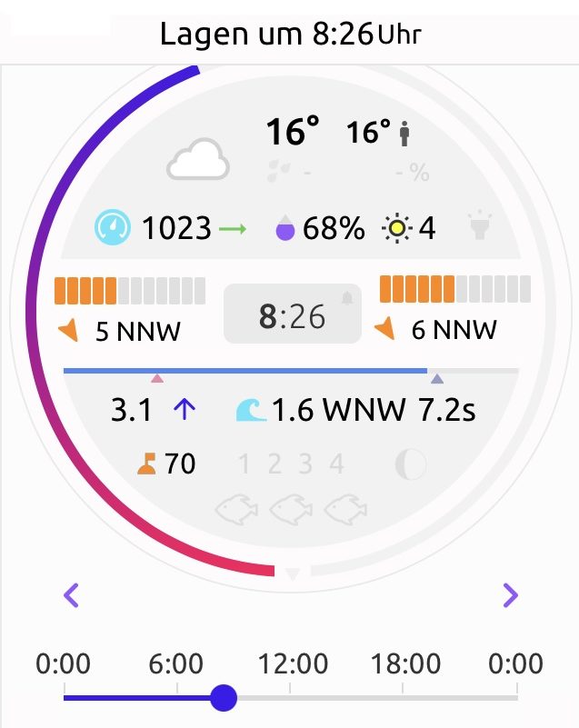
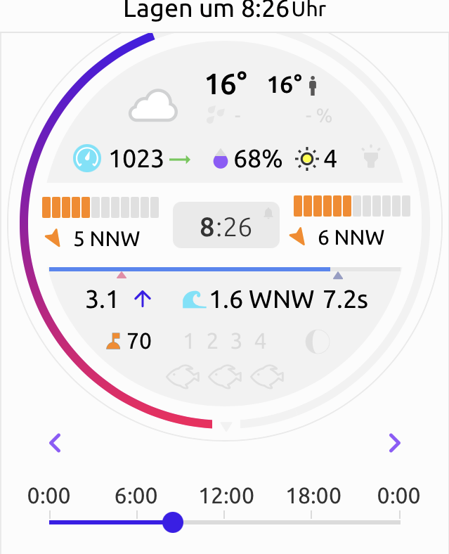 All apps show the wind with several wind speeds. Why is that? The wind is measured on land and at sea. That can make a real difference. A wind strength of 5 Beaufort on land does not mean that it is the same off shore. On the contrary. Our apps show often that the wind at sea is way stronger than on land. Maybe that’s not true directly along the shore, but 2-3 km away from land the circumstances are definitely different.
Our policy at Rowing-in-Europe is to only go out with very experienced crews when the waves are around or above 1.5 meters and the wind reaches 5 on the Beaufort Scale. After all, it’s blowing at a speed of 30-38 km and some crew members are always afraid that they won’t be able to cope with it.
The waves and the swell:
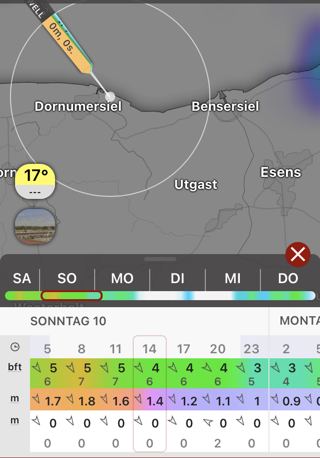
In addition to the wind, the waves and especially the height of the waves are of great importance. As an example: our apps show an average height of 1.1m to 1.8m throughout the day. This wave height is already a challenge for coastal fours and inexperienced rowers. Even with waves that might not be that high on the first look, only experienced crews should go out. 1.1.-1.8m means the average height, so about 14% of waves can be twice as high. Although seafarers speak of “moderately turbulent seas” with waves up to 2.5m, things can get a bit dicey for us rowers. Besides that, the direction and the interval of the waves are of importance as well. If waves have an interval of 7-8 seconds, it’s still comfortable for rowers. If the interval gets shorter it becomes more challenging.
The tide:
Tip: Especially where you can do mudflat hikes, you have to inquire about the exact route in detail. Look at the time of the tide and the coefficient. In the North Sea in East or North Frisia and other areas with a strong tide, the tide can determine if you have a nice, successful day in your Coastal Boat. When you are in an area with a high mudflat, you have to make sure, that you’re staying exactly in the tidal creeks. Otherwise, it can happen that you end up in the mudflat and have to wait 2-3 hours until the water comes back. Absolutely not recommended, especially on hot summer days.
Why is the tide coefficient important as well? It says something about the speed of the water. The difference between the level of the water at low tide and the level of the water at high tide results in the tidal range. The larger the difference between low and high tide – the higher the coefficient.
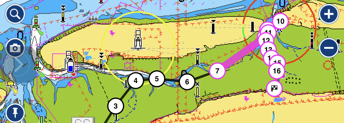
Tides with the highest coefficient follow days of the full moon and new moon. The highest possible coefficient is 120 and a coefficient between 50-70 is normal. We had a situation in North-Frisia with a coefficient of 88%, which meant that the water ran off quite quickly. And as the coefficient increases, so does the chance that the waves along the beaches of the North Sea and Atlantic will be higher and more powerful – as more water pushes onto the shore in a shorter period of time. It is possible that the high tide or the low tide will come earlier. In the case in question we just barely made it through the Wadden Sea. In the picture below you can see that the planner did not stick to the tidal creeks of the Wadden Sea. Why not? The crew rowed out an hour before high tide. With this, you could easily row over the mudflats. Otherwise, we always recommend staying in the tidal creeks which can be pretty wide, especially in the North Sea.
Coastal Rowing Tours and weather: Calculation of speed and distance
Please note that we always have to calculate two speeds and distances for coastal rowing. The speed that a coastal boat has in relation to the sea floor is not automatically the speed in relation to the water surface. For a tour of 15 km (above ground) we rowed about 20 km. Imagine you are rowing at a speed of 10 km/h and have a counter-current of 6 km/h. Above ground, you are 4 km/h fast. Under normal conditions, we calculate with a factor of 30% on the North Sea. This means that we add about 4.5 km extra for a 15 km tour. So when you plan your Coastal Tour, be prepared to add some extra kilometres.
Example: Minimum float plan weather data for your schedule on the Coastal Rowing Tour. To issue an appropriate tour plan you need to define more data about cruise, boats, environmental obstacles, ETD, ETA, or turning point. If you would like to have more information contact us .
| Day | Wind | Wa.S. | Waves /sec | Waves | HT | LT |
| 1 | 5 NW | 6 NW | 1.5 / 7.5 | WSW | 6.30 | 12.34 |
| 2 | 3 NNW | 6 NNW | 1.0 / 7.6 | NNW | 7.42 | 13.56 |
| 3 | 3 WSW | 3 W | 0.5 / 0.2 | WSW | 8.50 | 15.02 |
| 4 | 5 NW | 6 NW | 1.5 / 7.8 | NW | 10.04 | 16.12 |